Mars Rover Views Spectacular Layered Rock Formations


Mars Rover Views Spectacular Layered Rock Formations
The layered geologic past of Mars is revealed in stunning detail in new color images returned by NASA’s Curiosity Mars rover, which is currently exploring the “Murray Buttes” region of lower Mount Sharp.
The new images arguably rival photos taken in U.S. National Parks. Curiosity took the images with its Mast Camera (Mastcam) on Sept. 8.
The rover team plans to assemble several large, color mosaics from the multitude of images taken at this location in the near future.
“Curiosity’s science team has been just thrilled to go on this road trip through a bit of the American desert Southwest on Mars,” said Curiosity Project Scientist Ashwin Vasavada, of NASA’s Jet Propulsion Laboratory, Pasadena, California.
The Martian buttes and mesas rising above the surface are eroded remnants of ancient sandstone that originated when winds deposited sand after lower Mount Sharp had formed.
“Studying these buttes up close has given us a better understanding of ancient sand dunes that formed and were buried, chemically changed by groundwater, exhumed and eroded to form the landscape that we see today,” Vasavada said.
The new images represent Curiosity’s last stop in the Murray Buttes, where the rover has been driving for just over one month. As of this week, Curiosity has exited these buttes toward the south, driving up to the base of the final butte on its way out. In this location, the rover began its latest drilling campaign (on Sept. 9). After this drilling is completed, Curiosity will continue farther south and higher up Mount Sharp, leaving behind these spectacular formations.
Curiosity landed near Mount Sharp in 2012. It reached the base of the mountain in 2014 after successfully finding evidence on the surrounding plains that ancient Martian lakes offered conditions that would have been favorable for microbes if Mars has ever hosted life. Rock layers forming the base of Mount Sharp accumulated as sediment within ancient lakes billions of years ago.
On Mount Sharp, Curiosity is investigating how and when the habitable ancient conditions known from the mission’s earlier findings evolved into conditions drier and less favorable for life.
IMAGE 1….This view from the Mast Camera (Mastcam) in NASA’s Curiosity Mars rover shows an outcrop with finely layered rocks within the “Murray Buttes” region on lower Mount Sharp. The buttes and mesas rising above the surface in this area are eroded remnants of ancient sandstone that originated when winds deposited sand after lower Mount Sharp had formed. Curiosity closely examined that layer – called the “Stimson formation” – during the first half of 2016, while crossing a feature called “Naukluft Plateau” between two exposures of the Murray formation. The layering within the sandstone is called “cross-bedding” and indicates that the sandstone was deposited by wind as migrating sand dunes. The image was taken on Sept. 8, 2016, during the 1454th Martian day, or sol, of Curiosity’s work on Mars.
IMAGE 2….This view from the Mast Camera (Mastcam) in NASA’s Curiosity Mars rover shows a sloping hillside within the “Murray Buttes” region on lower Mount Sharp. The rim of Gale Crater, where the rover has been active since landing in 2012, is visible in the distance, through the dusty haze. The image was taken on Sept. 8, 2016, during the 1454th Martian day, or sol, of Curiosity’s work on Mars.
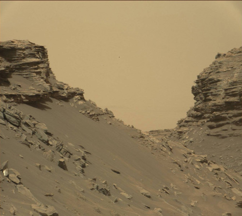
IMAGE 3….This view from the Mast Camera (Mastcam) in NASA’s Curiosity Mars rover shows sloping buttes and layered outcrops within the “Murray Buttes” region on lower Mount Sharp. The buttes and mesas rising above the surface are eroded remnants of ancient sandstone that originated when winds deposited sand after lower Mount Sharp had formed. Curiosity closely examined that layer – called the “Stimson formation” – during the first half of 2016, while crossing a feature called “Naukluft Plateau” between two exposures of the Murray formation. The layering within the sandstone is called “cross-bedding” and indicates that the sandstone was deposited by wind as migrating sand dunes. The image was taken on Sept. 8, 2016, during the 1454th Martian day, or sol, of Curiosity’s work on Mars.
IMAGE 4….This view from the Mast Camera (Mastcam) in NASA’s Curiosity Mars rover shows finely layered rocks within the “Murray Buttes” region on lower Mount Sharp. The buttes and mesas rising above the surface in this area are eroded remnants of ancient sandstone that originated when winds deposited sand after lower Mount Sharp had formed. Curiosity closely examined that layer – called the “Stimson formation” – during the first half of 2016, while crossing a feature called “Naukluft Plateau” between two exposures of the Murray formation. The layering within the sandstone is called “cross-bedding” and indicates that the sandstone was deposited by wind as migrating sand dunes. The image was taken on Sept. 8, 2016, during the 1454th Martian day, or sol, of Curiosity’s work on Mars.
IMAGE 5….This view from the Mast Camera (Mastcam) in NASA’s Curiosity Mars rover shows a hillside outcrop with layered rocks within the “Murray Buttes” region on lower Mount Sharp. The buttes and mesas rising above the surface in this area are eroded remnants of ancient sandstone that originated when winds deposited sand after lower Mount Sharp had formed. Curiosity closely examined that layer – called the “Stimson formation” – during the first half of 2016, while crossing a feature called “Naukluft Plateau” between two exposures of the Murray formation. The layering within the sandstone is called “cross-bedding” and indicates that the sandstone was deposited by wind as migrating sand dunes. The image was taken on Sept. 8, 2016, during the 1454th Martian day, or sol, of Curiosity’s work on Mars. Malin Space Science Systems, San Diego, built and operates the rover’s Mastcam. NASA’s Jet Propulsion Laboratory, a division of Caltech in Pasadena, manages the Mars Science Laboratory Project for NASA’s Science Mission Directorate, Washington. JPL designed and built the project’s Curiosity rover.
More Posts from Jpl-official-blog and Others

NGC 7023: The Iris Nebula : These cosmic clouds have blossomed 1,300 light-years away, in the fertile starfields of the constellation Cepheus. Called the Iris Nebula, NGC 7023 is not the only nebula to evoke the imagery of flowers, though. Still, this deep telescopic image shows off the Iris Nebulas range of colors and symmetries, embedded in surrounding fields of interstellar dust. Within the Iris itself, dusty nebular material surrounds a hot, young star. The dominant color of the brighter reflection nebula is blue, characteristic of dust grains reflecting starlight. Central filaments of the reflection nebula glow with a faint reddish photoluminesence as some dust grains effectively convert the stars invisible ultraviolet radiation to visible red light. Infrared observations indicate that this nebula contains complex carbon molecules known as PAHs. The pretty blue petals of the Iris Nebula span about six light-years. The colorful field-of-view stretches almost five Full Moons across the sky. via NASA
js
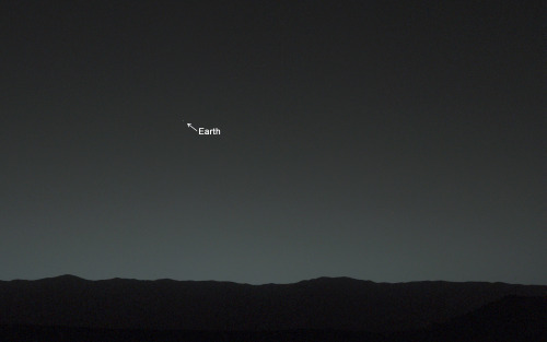
Earth, you are my wishing star. Here’s how you look from my home on the surface of Mars.

Curiosity Finds Active and Ancient Organic Chemistry on Mars
NASA’s Mars Curiosity rover has measured a tenfold spike in methane, an organic chemical, in the atmosphere around it and detected other organic molecules in a rock-powder sample collected by the robotic laboratory’s drill.
Researchers used Curiosity’s onboard Sample Analysis at Mars (SAM) laboratory a dozen times in a 20-month period to sniff methane in the atmosphere. During two of those months, in late 2013 and early 2014, four measurements averaged seven parts per billion. Before and after that, readings averaged only one-tenth that level.
Curiosity also detected different Martian organic chemicals in powder drilled from a rock dubbed Cumberland, the first definitive detection of organics in surface materials of Mars. These Martian organics could either have formed on Mars or been delivered to Mars by meteorites.
Organic molecules, which contain carbon and usually hydrogen, are chemical building blocks of life, although they can exist without the presence of life. Curiosity’s findings from analyzing samples of atmosphere and rock powder do not reveal whether Mars has ever harbored living microbes, but the findings do shed light on a chemically active modern Mars and on favorable conditions for life on ancient Mars.
For more information:
Mars methane detection and variability at Gale crater
Habitability, Taphonomy, and the Search for Organic Carbon on Mars
Recent Findings from NASA’s Curiosity Rover about Modern and Ancient Mars
Credit: NASA/JPL-Caltech/MSSS
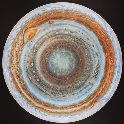
Jupiter’s south pole, taken by Cassini

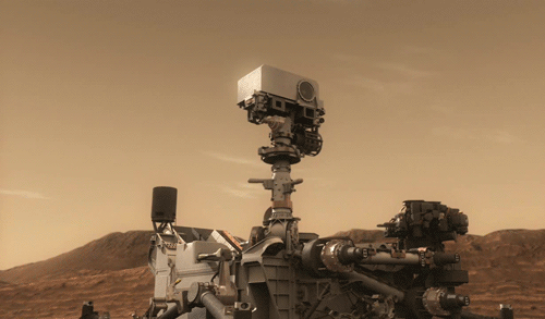
Nic Cage Rover analyzing a rock
Ahh, scientists. Impatient, but the best


Fifty years ago, a bunch of impatient scientists didn’t want to wait all day for a computer to compute the very first digital photo of Mars, so they colored the printout with pastels and made the print themselves.

Back-to-Back Friday Spacewalks
On Friday, Jan. 6 and Friday, Jan. 13, astronauts on the International Space Station will step outside to perform spacewalks.

What’s a spacewalk? It’s any time an astronaut gets out of a vehicle or spacecraft while in space. It can also be called an EVA (extravehicular activity).
Astronauts go on spacewalks for many reasons. These activities allow crew members to work outside their spacecraft (in this case the space station).

So what specific tasks will astronauts perform in these two upcoming spacewalks? Let’s take a look…
Both spacewalks are being performed to upgrade the orbital outpost’s power system.

The crew members will install adapter plates and hook up electrical connections for six new lithium-ion batteries that were delivered to the station in December.

NASA astronauts Shane Kimbrough and Peggy Whitson will perform the first spacewalk on Jan. 6. The work will continue Jan. 13 during the second spacewalk, which will be conducted by Kimbrough and ESA astronaut Thomas Pesquet.

Prior to each spacewalk, the new batteries will be robotically extracted from a pallet to replace 12 older nickel-hydrogen batteries through a series of robotic operations.
Watch LIVE Spacewalk Coverage
Friday, Jan. 6 Coverage begins at 5:30 a.m. EST, with astronauts venturing outside at 7 a.m. Watch HERE
Friday, Jan. 13 Coverage begins at 5:30 a.m. EST, with astronauts venturing outside at 7 a.m. Watch HERE
Watch for more…
Make sure to follow us on Tumblr for your regular dose of space: http://nasa.tumblr.com
Hues in a Crater Slope
NASA - Mars Reconnaissance Orbiter (MRO) logo. Jan. 4, 2017
Impact craters expose the subsurface materials on the steep slopes of Mars. However, these slopes often experience rockfalls and debris avalanches that keep the surface clean of dust, revealing a variety of hues, like in this enhanced-color image from NASA’s Mars Reconnaissance Orbiter, representing different rock types. The bright reddish material at the top of the crater rim is from a coating of the Martian dust. The long streamers of material are from downslope movements. Also revealed in this slope are a variety of bedrock textures, with a mix of layered and jumbled deposits. This sample is typical of the Martian highlands, with lava flows and water-lain materials depositing layers, then broken up and jumbled by many impact events. This image was acquired by the High Resolution Imaging Science Experiment (HiRISE) camera on Feb. 28, 2011 at 15:24 local Mars time. It is a stereo pair with image ESP_021454_1550. The University of Arizona, Tucson, operates HiRISE, which was built by Ball Aerospace & Technologies Corp., Boulder, Colo. NASA’s Jet Propulsion Laboratory, a division of Caltech in Pasadena, California, manages the Mars Reconnaissance Orbiter Project for NASA’s Science Mission Directorate, Washington. Additional image products: HiRISE, University of Arizona: http://www.uahirise.org/ESP_021520_1550 Mars Reconnaissance Orbiter (MRO): http://www.nasa.gov/mission_pages/MRO/main/index.html Image, Text, Credits: NASA/JPL/Sarah Loff/University of Arizona/Caption: Alfred McEwen. Greetings, Orbiter.ch Full article
-
 thecourtfool liked this · 5 years ago
 -
 theblackcat reblogged this · 6 years ago
 -
 entelekias reblogged this · 6 years ago
 -
 tsid11 liked this · 6 years ago
 -
 rileyix reblogged this · 7 years ago
 -
 mu-mesons reblogged this · 8 years ago
 -
 deadiphone liked this · 8 years ago
 -
 rinsci-blog reblogged this · 8 years ago
 -
 carrot2323 reblogged this · 8 years ago
 -
 madamairlock reblogged this · 8 years ago
 -
 dykendireckt liked this · 8 years ago
 -
 thepizzawasaggressive liked this · 8 years ago
 -
rinsci-blog liked this · 8 years ago
-
 sharkythefangirl reblogged this · 8 years ago
 -
sharkythefangirl liked this · 8 years ago
-
 thehomo-sapiensagenda liked this · 8 years ago
 -
 alesbiancalledflorence liked this · 8 years ago
 -
 ufo-official reblogged this · 8 years ago
 -
 rconeel liked this · 8 years ago
 -
 jpl-official-blog reblogged this · 8 years ago
 -
 running-with-toast reblogged this · 8 years ago
 -
 luxicaltric reblogged this · 8 years ago
 -
 knittingnoodle reblogged this · 8 years ago
 -
knittingnoodle liked this · 8 years ago
-
 yuukisynical liked this · 8 years ago
 -
 l-l--l---l----l-----l reblogged this · 8 years ago
 -
 march2206-blog reblogged this · 8 years ago
 -
 ahsokita-tano reblogged this · 8 years ago
 -
 aiguaka reblogged this · 8 years ago
 -
ahsokita-tano liked this · 8 years ago
-
 destopia liked this · 8 years ago
 -
 bradisrael reblogged this · 8 years ago
 -
bradisrael liked this · 8 years ago
-
 plinkesq-blog liked this · 8 years ago
 -
 teetas liked this · 8 years ago
37 posts